We did it

SierraSoft Land is a BIM software for land restitution, modeling and analysis.
With SierraSoft Land, you can handle land survey of any size carried out with various types of tools,
such as total stations, GPS, laser scanners, and drones.
The entire flow of rendering of acquired data, 3D surface modeling, and section and volume calculation
is managed in SierraSoft Land in a simple and comprehensive way.
BIM software for land surveying
Share, collaborate, communicate.

SierraSoft Land is a BIM (Building Information Modeling) software for land rendering and modeling. BIM rendering and modelling takes place via the BIM exchange functionality, which is part of the M3 framework, and is available exclusively with SierraSoft Subscription. BIM exchange is a powerful tool that allows the integration of topography, infrastructure and construction projects within the processes, guidelines, and tools used with BIM.
Data acquisition
Use the data you have, without limitations.
Your work starts with the data you have, whether it’s points surveyed with a total station, GPS, laser scanners, or drones. SierraSoft Land has the functions to import and make your information usable; you can have a few points or a huge survey, it will be easily manageable in both cases.
Survey rendering
Manage all the information while completing and enhancing it.
 |
|
If you have a traditional survey performed with points and you used codes, the entire design can be created automatically. If instead you have a point cloud, you can use the digital survey functions to survey as if you were in the countryside. You can also take advantage of the support features to render photos, satellite imagery, digital maps, and other models. |
Surface modeling
Create accurate 3D terrain surfaces.

Generate accurate 3D surfaces with just a few steps, while maintaining control over the outcome.
Thanks to its discontinuities management and high processing speed, you can easily manage small models
up to the triangulation of a large point cloud. You can complete the job with contour lines.
Cross sections
Extract and manage sections of your 3D models.

The sections can be automatically extracted either along a direction or along a polygonal alignment.
Through the extraction styles, you can extract complex sections using multiple 3D surfaces in one step.
Volumes
Calculate volumes with the best method.
You can calculate volume with different methods, depending on your data and your goals.
The calculation can be done either using a model’s triangular surfaces or extracted sections.
The calculation for triangular surfaces is quite simple to use and extremely precise.
Point clouds
Upload and manage point clouds in a very simple way.

Easy handle one or more point clouds of any size. Loading and display are really fast, drawing and extraction functions occur in real time. With just a few click you can extract models and calculate volumes in many different ways. A special tool “SierraSoft Mass Data Convertes” allows to convert LAS, XYZ, PTS and XCF files so that you are able to handle them with SierraSoft Land.
3D Design
Easy design of complex surfaces.
You can easily design any surface with the immediate 3D representation of the result.
Design features include the creation of leveling, sideslopes, polylines offset, connection surfaces and the merging models and surface. Get quickly extremely precise project 3D model as far as the creation of sideslopes and intersections with the existing terrain model. Enjoy designing pits, dumps, parking areas, terracing, embankings, ramps, tracks and all what is concerned with the design of models.
Multi. Multi. Multi.
Multiply your workspace.
Expand the space where you manage your surveys and models at will:
split your work between multiple windows, pages, or monitors. All data and views are synchronized in real time.
Begin a drawing in one window and continue it in another on a separate monitor.
Discover a new dimension for working.
Mega projects
When size matters.
|
|
System requirements
- Microsoft® Windows 10, Windows 8, Windows 7.
- 32 bit (x86) or 64 bit (x64) processor 1 GHz or more.
- 2 GB minimum RAM (4 GB recommended).
- 2 GB hard disk space.
- Display Resolution 1280×1024 True Color (1600×1050 or more recommended).
- Browser Windows Internet Explorer® 9.0 (or later).
- DVD-ROM.
Technical details
|
GENERAL |
|
|
|
|
|
AVAILABLE LANGUAGES |
|
|
|
|
|
BIM |
|
|
|
|
|
CAD |
|
|
|
|
|
IMAGES AND PICTURES |
|
|
|
|
|
SURVEY |
|
|
|
|
|
MODELS |
|
|
|
|
|
3D DESIGN |
|
|
|
|
|
POINT CLOUDS |
|
|
|
|
|
CROSS SECTIONS |
|
|
|
|
|
QUANTITY AND COSTS |
|
|
|
|
|
COMPATIBILITY |
|
M3 framework
Future starts here.

|
M3 framework is the new software platform aimed to create a new generation of applications for Land surveying, Infrastructures Design and for Constructions. M3 framework is a powerful, flexible and stable software platform where fulfill products and services. |
User Interface.
Beautiful and functional.

The ergonomic and refined Interface is focused on the user’s experience.
The result is a simple and effective Interface with a wider graphic area
and the access to features is natural and more intuitive.
Graphic engine.
Extraordinarily fast.
 |
|
|
|
A special flexible and very high-performance 3D graphic engine. |
Database.
A stable base for your projects.
 |
|
Memory manager.
Everything you need without waste.
 |
|||
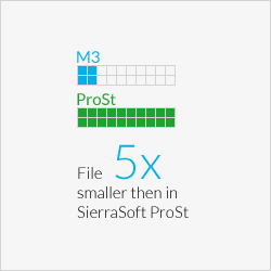
1 GbSierraSoft ProSt |
2GbM3 framework on Windows 32Bit |
64GbM3 framework on Windows 64Bit |
|
|
M3 framework can use all the available memory on the system (2GB for Windows 32bit and 64GB for Windows 64bit). It has an optimized management, which uses just the necessary memory and free memory as soon as possible. |
|||
International.
Work without boundaries.
 |
M3 framework is international by nature and manages different languages and several units of measure. Thanks to the management of Unicode characters, it is possible to use all currently used writing systems, as Japanese, Chinese, Hindi, Arabic, etc. It is possible to choose from different languages among the Interface, the design data and the reports. In this way it will be possible to work with your favorite language and choose the one requested by the client for the finished work. |
Teamworking.
The advantage of working in team.
 |
|
|
The M3 framework offers a messaging and notifications system among the users of the same project. |
Help.
Learning by doing.
 |
Learning tools are included in the M3 framework. The Smarthelp guides the user while working with the software by providing context-sensitive information. The user guide of the product is integrated in the Interface through retractable control panels and always available. |
Supported systems.
|
M3 framework allows the development of products both for 32Bit and 64Bit Window platforms |
|
 |
ACE-Hellas S.A.
Integrated Solutions