We did it

We did it!
We changed everything starting and re-designing everything from the very beginning. We were looking for the most to give you the best: ease of use, extraordinary performance, functional design. We have decided to run with our know-how in order to create new technologies. We reflected and designed over and over as to give excellent: working environment, CAD, alignment design, input of longitudinal profiles and cross-sections, design of the road intersections. We neither gave up nor were satisfied until we found the best solution. The future of road and highway design starts from SierraSoft Roads.
New software platform
M3 framework.
Future starts here.
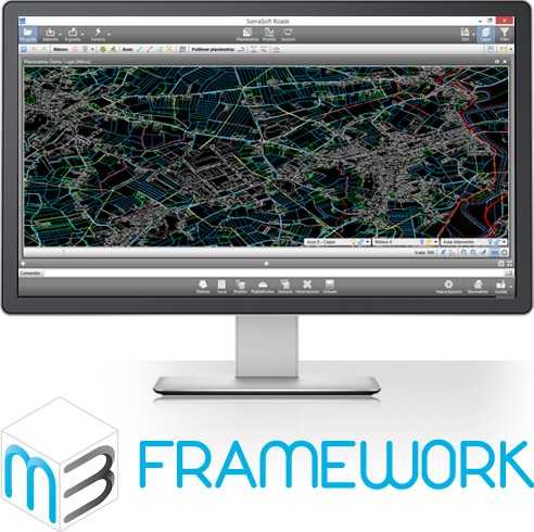
M3 framework is the new software platform aimed to create a new generation of applications for Land surveying, Infrastructures Design and for Constructions. M3 framework is a powerful, flexible and stable software platform where fulfill products and services.
Multiply
Multiply your working space.

Extend at will the space where to manage your projects.
Split your project in several windows, pages and monitors.
All data and views are synchronized in real time.
Start a project in a window and continue working on it in another window on another monitor.
Discover a new working dimension.
Mega projects
When size does matter.

|
100+Hundreds of alignments 1000+Thousands of sections 1.000.000+Millions of triangles and massive point clouds |
|
Thanks to SierraSoft Roads it is possible to manage with big quantities of data. |
|
Alignment design
Alignment design in a natural way.

A new system with a few essential commands allows to solve complicated cases
in a natural way through grips, properties and intelligent objects.
Everything is displayed in real time and can be verified due to the current policy.
The alignment design has never been so easy.
Modification and control
Set to zero waiting times between the changes and the final results.
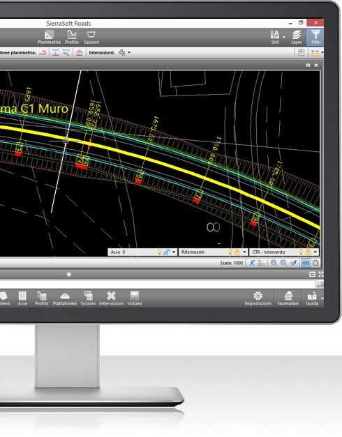
It is possible to control the design like never before, drastically reduce designing time thanks to 3D real time cross-section on planimetry.
By changing a parameter everything is updated automatically. The result can be immediately checked even before creating the final project. Maximum control over the entire design and over every detail.
Creation
Create the project with one click.

 |
It is possible to create a project with incredible ease. |
Intersections
Even simpler.
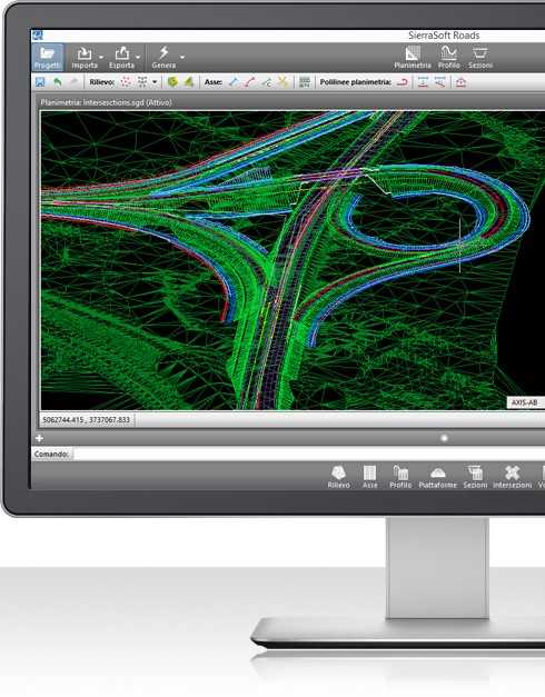
Whether it’s roundabouts, at-grade intersections or complex interchanges, you can design them with SierraSoft Roads fast and accurately as never before. With a few click you can create and directly change them in 3D on planimetry.
Road and highway
Free to design where you prefer.

Design according to the road and highway design standards you need. Thanks to an open and smart system, you can extend the road and highway design standards with the new one you need. You can validate the calculations and verify the used functions and procedures.
Thanks to this system you can work with no limits and have control over the project in real time.
BIM
Sharing of information, communication and collaboration.

SierraSoft Roads is a BIM software for the infrastructures.
Data include physical and functional features of the several parts of a project
becoming a database of sharing of knowledge, useful during the entire designing process.
System requirements
- Microsoft® Windows 10, Windows 8, Windows 7.
- 32 bit (x86) or 64 bit (x64) processor 1 GHz or more.
- 2 GB minimum RAM (4 GB recommended).
- 2 GB hard disk space.
- Display Resolution 1280×1024 True Color (1600×1050 or more recommended).
- Browser Windows Internet Explorer® 9.0 (or later).
- DVD-ROM.
Technical details
GENERAL |
|
CAD |
|
SURVEY AND MODELS |
|
ALIGNMENT |
|
PROFILE |
|
INTERSECTIONS |
|
TYPICAL SECTIONS |
|
CROSS SECTIONS |
|
ROAD AND HIGHWAY
|
|
COMPATIBILITY |
|
M3 framework
Future starts here.

|
M3 framework is the new software platform aimed to create a new generation of applications for Land surveying, Infrastructures Design and for Constructions. M3 framework is a powerful, flexible and stable software platform where fulfill products and services. |
User Interface.
Beautiful and functional.

The ergonomic and refined Interface is focused on the user’s experience.
The result is a simple and effective Interface with a wider graphic area
and the access to features is natural and more intuitive.
Graphic engine.
Extraordinarily fast.
 |
|
|
|
A special flexible and very high-performance 3D graphic engine. |
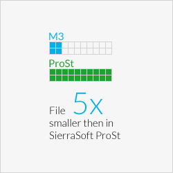
Database.
A stable base for your projects.
 |
|
Memory manager.
Everything you need without waste.
 |
|||
1 GbSierraSoft ProSt |
2GbM3 framework on Windows 32Bit |
64GbM3 framework on Windows 64Bit |
|
|
M3 framework can use all the available memory on the system (2GB for Windows 32bit and 64GB for Windows 64bit). It has an optimized management, which uses just the necessary memory and free memory as soon as possible. |
|||
International.
Work without boundaries.
 |
M3 framework is international by nature and manages different languages and several units of measure. Thanks to the management of Unicode characters, it is possible to use all currently used writing systems, as Japanese, Chinese, Hindi, Arabic, etc. It is possible to choose from different languages among the Interface, the design data and the reports. In this way it will be possible to work with your favorite language and choose the one requested by the client for the finished work. |
Teamworking.
The advantage of working in team.
 |
|
|
The M3 framework offers a messaging and notifications system among the users of the same project. |
Help.
Learning by doing.
 |
Learning tools are included in the M3 framework. The Smarthelp guides the user while working with the software by providing context-sensitive information. The user guide of the product is integrated in the Interface through retractable control panels and always available. |
Supported systems.
|
M3 framework allows the development of products both for 32Bit and 64Bit Window platforms |
|
 |
ACE-Hellas S.A.
Integrated Solutions